Western Australian Boat Launching Sites - Information
Hi Folks,
I've been mulling over this idea recently. I've often been asked for info on launching at Emu Point - Oyster Harbour down in Albany and thought it might be a good (or cr*p) idea to collate info on boat launching at various locations.
This doesn't have to just be about hard stand boat ramps, it can include beach launch locations as well. In fact, in regards to the latter, often it is more important as there's usually no man-made channel and therefore natural underwater obstacles/reefs/bombies to consider, and then there is also weather/swell considerations due to diminished shelter. Other considerations with a beach launch could include how hard/soft the sand is (type pressure requirements), condition of access track etc.
Each post on a location/facility could look something like this: (although open to suggestions/improvements if there is interest, willingness to commit etc).
These can be periodically updated when people use these facilities/visit locations.
----------------------------------------------------------------------------------------------------------------------------
LOCATION/Sub Location/Facility - ALBANY/Emu Point Boat Ramp
LAUNCH TYPE/Facilities - PUBLIC RAMP/2 Concrete Ramps with central slim finger.
INSIGHTS:
- Gets very busy Christmas/School Holidays so best to get down before 07:00 am.
- Tendency for non trailored cars to park in boat bays - no bosun or other control.
- Good ramps with shallow decline.
- A long bending, often narrow channel leads out to King George Sound. The channel is well marked, but care must be taken not to run aground.
- Care must be taken when launching/retreiving due to the number of pedestrians and cyclists - especially during the busy season.
EMERGENCY COVERAGE - Albany Sea Rescue (VMR610) base station is located here and therefore provides 24 x 7 coverage.
You get the idea. :)
Thoughts folks?
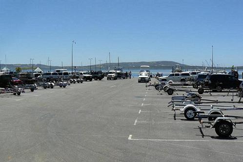
OH! One more thing. We could include at least one pic in each post - you could even mark it showing best route in/out - identify obstacles - any pointers on the pic that would be of assistance.
CAR PARK SHOT ON BOXING DAY - will get better pic next time I'm down:
Regards
Colin
Soon to be de "dreamweaver" ed!


Adam Gallash
Posts: 15665
Date Joined: 29/11/05
TANTABIDDI BOAT RAMP EXMOUTH
LOCATION: Tantabiddi Boat Ramp, Exmouth
LAUNCH TYPE/Facilities - New ramp completed March 2012
INSIGHTS:
- Gets very busy March through to August on good days.
- The moored areas are 8 knots.
- Remember to have a cold beer for the drive back to town!
EMERGENCY COVERAGE
- Exmouth Sea Rescue is manned on the weekends and monitored during the week.
Just after launch, what the old ramp looked like.
Site Admin - Just ask if you need assistance
Dreamweaver
Posts: 4688
Date Joined: 01/12/07
SWAN YACHT CLUB
LOCATION/Sub Location/Facility - EAST FREMANTLE/Between Aquarama and Leeuwin.
LAUNCH TYPE/Facilities - PRIVATE RAMP/1 Concrete Ramps with medium finger with front L.
INSIGHTS:
- Must be a member to legally use it - though they make exceptions on the Rotto swim boat support.
- Shallow decline ramp that, due to river weed, can get very slippery - excellent for aquatic single point landings on your bum!
- Very limited parking.
- Great bar facilities overlooking the water.
- No Boson supervision so can be dissapointing from a idiot free launch vs fees.
- Absolute PR*CK of a current at times and the unwary can end up playing (not so)dodgem cars with the pen sticks nearby.
- Don't even try and find an evening parking spot if there is a function on.
- No designated boat trailer bays - first come first served.
EMERGENCY COVERAGE - Fremantle Sea Rescue provides 24 x 7 coverage for typical areas fished.
Colin
RECFISHWEST Member 576
VMR 610 - Albany Sea Rescue - Mariner 421
Soon to be de "dreamweaver" ed!
Salmo
Posts: 913
Date Joined: 15/08/05
Hopetoun Ramp
LOCATION/Sub Location/Facility - Hopetoun
LAUNCH TYPE/Facilities - PUBLIC RAMP- 1 Concrete Ramps with side jetty
INSIGHTS:
- Gets very busy Christmas/School Holidays
- Heaps of Parking
- Good ramps with shallow decline.
- Travel north to get around reef. Markers easy to see
- North facing so doesnt get the rolling southern swell but you still need to be careful
Good Pub on the right just as you pull up onto the main road
EMERGENCY COVERAGE VMR604 CH 90
Salmo
Posts: 913
Date Joined: 15/08/05
Salvation Harbour Ramp
LOCATION- South east Coast -Salvation Bay Jerramungup Shire
LAUNCH TYPE/Facilities - PUBLIC RAMP/ 1 Beach Launch
INSIGHTS:
- Bush ramp used mainly by locals, campers and commercial salmon fishermen
- Sand ramp with gravel over the top
- Faces south into a protected bay but still suffers from swell.
- Difficult retreive with a southwester
- Once launched you need to head slightly east before turning the corner north west.
- often weeded up during winter
EMERGENCY COVERAGE - NO RESCUE SERVICE -Highly recommended to let someone know your intended return
Salmo
Posts: 913
Date Joined: 15/08/05
Esperance Harbour Boat ramp
LOCATION/Sub Location/Facility - Esperance Fishing Boat harbour Public Ramp
LAUNCH TYPE/Facilities - PUBLIC RAMP- 2 Concrete Ramps with finger jetty
INSIGHTS:
- Gets very busy Christmas/School Holidays
- Heaps of Parking
- Good ramps with shallow decline.
- Turn west to head out through the breakwall
- Protected launching
-Toilets and water near the ramp
EMERGENCY COVERAGE
Local Sea rescue VMR601 channel 88
VHF only when I was down there
24hr Rescue mobile number is 0419 869 655
The local Angling Club welcomes visitors on Friday nights for cheap beer and a great barbeque.....situated close to the ramp
Salmo
Posts: 913
Date Joined: 15/08/05
Bremer Bay Fishing Boat Harbour
LOCATION/Sub Location/Facility - Bremer Bay Fishing Boat harbour Public Ramp
LAUNCH TYPE/Facilities - PUBLIC RAMP- 2 Concrete Ramps with finger jetty
INSIGHTS:
- Gets very busy during summer Holidays
- Heaps of Parking
- Good ramps with shallow decline.
- Turn south west to head out through the harbour
- Protected launching though you still need to be careful during heavy swell
-Fish Cleaning facilties, Toilets and water near the ramp
EMERGENCY COVERAGE
Local Sea rescue VMR607 channel 88
Adam Gallash
Posts: 15665
Date Joined: 29/11/05
Port Gregory
Information provided by Bouttime.
LOCATION/Sub Location/Facility - Port Gregory, Access to Abrohlos Islands/ North island
LAUNCH TYPE/Facilities - PUBLIC RAMP - Beach launch
INSIGHTS:
- Not a well used ramp, shelter from the ocean with a reef for protection
- Dirt carpark to park car and trailer
- Soft sand so will need ramps to assist when pulling the boat out.
- Unmarked chanel but with an up to date chart you can see the enterance
- Care must be taken when launching/retreiving due to soft sand. Check first to make sure
EMERGENCY COVERAGE - Contact either Geralton or Kalbarri by phone as not to sure about radio coverage.
There is a small shop for food and drinks and a caravan park for fuel. It is best to take everything you need.
Site Admin - Just ask if you need assistance
Adam Gallash
Posts: 15665
Date Joined: 29/11/05
Coral Bay Boat Ramp
LOCATION/Sub Location/Facility - Coral Bay Boat Ramp
LAUNCH TYPE/Facilities - 2 boat slips, 1 finger jetty and 2 commercial offload points
INSIGHTS:
- New ramp
- Small turn around area for larger trailers
- Potential for extreme congestion in peak season
- Large car park, but 500m walk to vessel.
- Good shore based fishing location
- Beach launch from Bill's Bay is now offlimits
EMERGENCY COVERAGE
Coral Bay Sea Rescue (unsure of details)
Photos courtesy Tailor Marc, March 2015
Site Admin - Just ask if you need assistance
Adam Gallash
Posts: 15665
Date Joined: 29/11/05
Peaceful Bay Boat Ramp
LOCATION/Sub Location/Facility - Peaceful Bay
LAUNCH TYPE/Facilities - Beach Launch
INSIGHTS:
- Easy beach launch on good days.
- Be careful when parking your vehicle after launch, tide and swell moves the beach significantly some days.
- Swell over 2.5-3 meters can have dangerous set waves break accross the bay
- Water movement on retrieval can make life difficult. Having deflated tyres before launch will certainly increase chances of successful retrieve.
- Can possibly bribe locals to retrieve with tractor if the conditions turn bad.
- Popular on holidays, its a good thing to see other boats out there in that stretch of water!
EMERGENCY COVERAGE
PEACEFUL BAY SR
VMR 616
9840 8108
C/- Post Office
Peaceful Bay 6333
Site Admin - Just ask if you need assistance
Andy Mac
Posts: 4778
Date Joined: 03/02/06
Mindarie
LOCATION/Sub Location/Facility - Mindarie Marina Public Ramp
LAUNCH TYPE/Facilities - PUBLIC RAMP- 4 Concrete Ramps with 2 finger jetties
INSIGHTS: -
- Heaps of Parking - Reasonable ramps with shallow decline.
- Jetties do not have any protective rubbers at the moment so best use your own bollards
- Turn west as you head out from the marina, you will notice two reef breaks. One is inshore about 1nm north west of the entrance (Quinns Rocks) and the other main break is Directly west (Staggies Reef). Both these reefs break in anything over 1m swell so should be visible. If travelling west take the south west leads, just to be safe as the major reef line can break in different places when swell is up over 2m.
- Protected launching and retrieving allthough there is only one retrieve lane, so either time your return or expect a lengthy delay to retrieve.
- 2 Pubs very close by and washdown facilities in the carpark.
EMERGENCY COVERAGE Local Sea rescue VJ6LQ channel 90 for log on and log off. Bad reception inside the marina so make sure you log on and off about 500m outside the marina.
Hopefully someone has a good pic.
Cheers
Cheers
Andy Mac (Fishwrecked Reeltime Editor & Forum Moderator)
Youngest member of the Fishwrecked Old Farts Club
Salmo
Posts: 913
Date Joined: 15/08/05
Guilderton Groyne -Moore River
LOCATION/Sub Location/Facility - Guilderton Ramp
LAUNCH TYPE/Facilities - Beach Launch with shallow decline
INSIGHTS:
- Small boat launching only....nothing over 5m unless you have a tractor
- Dangerous during periods of heavy swell
- Limited Parking on the beach
- can be busy in the mornings during summer Holidays
- Un-protected launching, old rock groyne needs repair....need to be careful
- take note of the 4WD recovery number posted on sign at the ramp.
- Normally not servicable during late winter due to beach washing away
- Only a rubbish bin....no other services
EMERGENCY COVERAGE
Local Sea rescue is Two Rocks on CH91
pgreen1
Posts: 395
Date Joined: 20/02/08
Augusta
LOCATION/Sub Location/Facility - Augusta Boat Ramp, Augusta
LAUNCH TYPE/Facilities - 3 concrete / timber ramps, 3 different inclines ( Gradient of ramp ), finger jetty for two of the three lanes
INSIGHTS:
- Easy launching for small to larger boats
- Surge from swell can be an issue if the swell is up
- Free parking
- Small reef in front of the ramp needs to be watched when leaving the ramp. Safe passage is clearly marked
- No wash down facilities
- Ample parking close to the ramp, with toilets near by
- Timber can be slippery when wet.
EMERGENCY COVERAGE
Local Sea Rescue - local sea rescue VHF
Enjoy a good hard ...... Fish
Hutch
Posts: 2221
Date Joined: 21/04/13
Closed now, need to launch
Closed now, need to launch at new marina around the point
Stevef
Posts: 478
Date Joined: 27/02/08
Moore River Boat Ramp
Head down to the river (left at the servo, off the main road coming in) down to where the fish & chips shop, BBQ, Caravan Park etc is all located.
The boat ramp is basically at the eastern end of the car park.
Not a bad ramp as long as the water level is up. Just be careful heading up river as it can be very shallow in some areas
Steve
Mark K
Posts: 27
Date Joined: 16/01/09
Duke Caravan Park via Esperance
LOCATION/Sub Location/Facility - Duke Caravan Park east of Esperance
33°55'24.55"S 122°34'45.95"E
LAUNCH TYPE/Facilities - Sand, 4 wd required. Small boats may be ok for 2wd as sand is normally very hard.
INSIGHTS:
- Free parking
- Wash down facilities
- Ample parking close to the ramp, not sure about toilets
It would be helpful if people stated suitable for 2wd or 4wd and gps data for car or handheld units so that you can find where the boat ramp actually is, not just the town. Phones often have gps built in. You could put that info into google and look at it before you leave. I found finding Salvation Harbour took a bit of searching and if I didn't know Guilderton fairly well, wouldn't find the boat ramp from the details on here.
Mark K
Posts: 27
Date Joined: 16/01/09
Port Denison / Dongara
LOCATION/Sub Location/Facility - Port Denison Boat Ramp
Northern groyne of marina
29°16'16.03"S 114°55'14.13"E
LAUNCH TYPE/Facilities - 1 concrete ramps, no finger jetty.
INSIGHTS:
- Easy launching for small to larger boats
- Free parking
- No wash down facilities
- Ample parking close to the ramp
- Don't think toilets at boat ramp but there are public toilets about 300 m south near the jetty with shops there as well and still within the marina.
Adam Gallash
Posts: 15665
Date Joined: 29/11/05
Carnarvon Boat Ramp - Courtesy of Carnarvonite
Site Admin - Just ask if you need assistance
bod
Posts: 2321
Date Joined: 03/05/06
new Carnarvon boat ramp 23/12/11
Carnarvon boat ramp opens for public use
Boat owners in the Gascoyne have been given access to the new Carnarvon Boat Ramp in advance of the formal completion of the $3 million project.
Department of Transport (DoT) General Manager Coastal Infrastructure Steve Jenkins said the facility's new parking area, with provision for up to 77 vehicles and trailers, had been completed along with work to raise the inshore sections of the jetties.
"While not fully complete the project is at a stage where the marine infrastructure is in place and the facility is safe to use," Mr Jenkins said.
"The final stage of the project including the construction of a toilet block and fish cleaning facilities will start early in the new year and once complete will complement the existing facilities on site."
Mr Jenkins said boat owners using the new ramp were reminded to observe recently introduced safety measures for the Fascine.
DoT in consultation with the Gascoyne Community Boating Group, the Shire of Carnarvon and relevant government agencies, developed a formal Aquatic Use Plan for the Fascine to increase safety and avoid future conflict between users.
The changes cover all the waters of the Fascine extending from the North Water Estate, Whitlock Island, downstream to Teggs Channel and include:
Adam Gallash
Posts: 15665
Date Joined: 29/11/05
Leeman Boat Ramp
Thanks to Roberta and Bob Kennington.
Leeman Town ramp at low tide.
Sea Rescue Ramp both with weed, Summer time is just sand.
Another angle of Sea Rescue Ramp
Leeman has two ramps, one is called Town Ramp and you can get in and out with 4WD or 2WD (if careful). Have to put up with a lot of weed, especially if council doesn't clean frequently. Get in early not a lot of parking.
Second ramp is the Sea Rescue ramp which was put in privately and is slightly steep and slippery with sand. It's better to use 4WD, not bad parking but get in early if you don't want to walk too far, follow bouys out, reefs depending on tide.
Apparently sea rescue has applied for funding for new jetties, approved but when will it happens? Southerly blows bit tricky on both ramps to retrieve with surge but usually somebody is around to give each other help on surgie days.
Hope these photos help, I think this is very good idea gives boaties chance to see what they are in for when going away to spots you don't know.
Greenhead has fantastic ramps, plenty of parking also Jurien Bay excellent. Also Leeman Sea Rescue.
Site Admin - Just ask if you need assistance
Pete D
Posts: 1681
Date Joined: 07/06/07
HAMELIN BAY
Pic from Ocean with my trailer preparing for retreive; note, plenty of viewing seats to watch the entertainment;
Sunday arvo saw about 4 trailers washed sideways off the concrete, one nearly broken leg as boat washed sideways onto bloke, 5 cables snapping, one boat on the concrete, one trailer popping off the tow ball. Surprising how many do not engage 4WD when using a 4WD!
Worst was the group that had all of the above (I was helping with the winching, thinking this rusty piece of crap is going to ........snap!).
No problems with my rig though, good organised crew helps with back up plans and 1st low engaged.
Was a 2 metre swell outside.
Cheers Pete
CARNARVONITE adds: Wood bridge down to concrete end, which is above beach level. Single lane, ample parking nearby. 4x4 recommended as usually very slippery where concrete meets wood bridge section. If first one there in the morning usually have to remove seaweed [kelp] from ramp. Lots of care needs to be taken when swell is above 1.5 metres outside [concrete end higher than beach causes trailers to wash sideways off ramp]
Adam Gallash
Posts: 15665
Date Joined: 29/11/05
Check this - Boat launching ramps in the Swan river:
Also check this page for boat launching ramps in the Swan river:
Thanks to Geoff (GPC123)
http://fishwrecked.com/node/22755
Site Admin - Just ask if you need assistance
mitch
Posts: 1285
Date Joined: 14/08/05
beadon creek boat ramp, Onslow
one of the best ramps around .only a single ramp but sheltered from the wind and pretty much any tide you can get in or out without to many probs unless your launching an 7.5 plus if so ide be looking at least mid tide
the floating jetty is what makes the ramp so enjoyable to use .instead of the likes of exmouth ,dampier port headland with big tides if you come in on a low your usualy climbing some barrnicle encrust rusty old ladder to get on the walk way .if your putting things into your boat youve either got wet feet [high tide] or ya passing things down to people in the boat.[low tide].the walk ways are usually that non slip sharp as steel griddy stuff .not onslow good old timber and the level of your boat is always constant to the walway with ease you can embark and disembark.and the best bit tyhe fishing rocks
Adam Gallash
Posts: 15665
Date Joined: 29/11/05
Bundegi Boat Ramp
LOCATION/Sub Location/Facility - Bundegi Boat Ramp, Exmouth
LAUNCH TYPE/Facilities - Jetty
INSIGHTS:
- Long reverse to water line
- Tidal movement important on launch/retrieve times - strong surge
- Time consuming retrieve for inexperienced backers
- Filleting table is up the other end of the beach behind the jetty
- Sandflies can make it unbearable standing about without aerogaurd
- On low tide under .4m big boats get stuck on the sandbar and can't retrieve/launch
- Very busy during peak season - patience is required
- On low tide its easy to back off the ramp onto the rocks - trailer makes a large thump as it drops off the end of ramp
EMERGENCY COVERAGE
Local Sea Rescue - Often manned only on weekends (off season) - VHF 72 and 27 meg 88 or 90
replaces this:
LOCATION/Sub Location/Facility - Bundegi Boat Ramp, Exmouth
LAUNCH TYPE/Facilities - Small concrete area constantly covered in sand
Site Admin - Just ask if you need assistance
dagree
Posts: 660
Date Joined: 08/12/07
Dunsborough Ramps
The old dunsborough ramp is on the eastern side (or is it southern???? anyway it is on the other side of town to Perth) Is reasonable but not sure if you have a big boat. The other one is at Quindalup... follow the beaches from Dunsborough back toward Busselton for a few kms and you will find it. Both are suitable for 2wd but quindalup can get nasty when the wind comes around the Cape.
Cheers,
David (AKA Grumps)
Location: Heathridge. Toys: 120 Series Prado ... 5.3 Stacer Seamaster/Merc 90HP.
Mainey
Posts: 177
Date Joined: 17/09/10
Old Dunsborough ramp
The Old Dunsborough ramp is a bugga of a ramp for launching by just one person, the area surrounding it is rocks with just a small area ( maybe less than 2 Mtrs) of sand surrounded by rocks, this is the only place where you can place the boat while you take the trailer back up to the free carpark area.
I use it when I go out into the Southern Ocean, rather than run down the coast from the terrific facilities up in Busselton which I use if I'm going out to Geographe bay reef area.
Maîneÿ . . .Mainey
Posts: 177
Date Joined: 17/09/10
Dunsborough area ramps
I now use the Quindalup concrete ramp at the sea rescue base on Geographe bay just a bit north of town.
Has a reasonable jetty and 2 ramps, one each side, can recoment it.
Also has plenty of parking and amenitities
Maîneÿ . . .MattMiller
Posts: 4171
Date Joined: 15/06/09
You'll find
that it's East of Dunsborough Mainey at Quindalup. If you were to head North you may get a little wet Common mistake
carnarvonite
Posts: 8708
Date Joined: 24/07/07
Quindalup
As Dagree has said follow the beach east from Dunsborough township or if you are coming from Bussellton turn right at the roundabout before the golf course.The first small ramp is the professionals ramp and is a no no[the rangers love writing tickets].The main ramp is another 1 km further on
wide open
Posts: 444
Date Joined: 24/12/09
carnarvonite or anyone who knows
in carnarvon is the south fascine ramp or the pelican point ramp better for launching bigger boats
that pelican point ramp is so bloody slippery aint it
carnarvonite
Posts: 8708
Date Joined: 24/07/07
Boat Harbour
The ramp in the fishing boat harbour is the better ramp than Pelican point. Its got the nobbly concrete base not like the smooth one a Pelican point plus there is the jetty. High tide can sometimes be a problem because there isn't too much slope on the top part of the ramp. I've found it easier to put the hubs in and use the right hand/sand side. If you are on your own with a smaller boat retrieving on that side is easier, all you do is park the trailer close to the jetty so the boat doesn't get blown round in the sea breeze
Cammos
Posts: 606
Date Joined: 30/06/09
Busselton
I am heading down to Busselton next week.
I have seen boat trailers parked about 3-4km south of the Busso Jetty. On GoogleEarth it looks like a little beach launch. It is the corner of Geographe Bay Rd and Dolphin Rd. Would I be OK getting a 6m glass boat in there? I am staying at Mandalay so I may have to head to Port Geo Marina if not. Any other suggstions?
dagree
Posts: 660
Date Joined: 08/12/07
Dolphin Rd Boat Ramp
Cammos, We are at Mandalay at the moment. Dolphin Rd ramp is only 500 mtrs up the road. Talk to Clive (Park owner) and he will happily tell you more. Assuming you have a 4WD? If so you should have no probs as we get our 5.5m (old/heavy) glass boat in and out from there. Just be weary if someone has come down without selecting 4WD as it can get chewed up a bit if they do a u-turn. Another option is "Newton Beach Ramp". A few K's west towards Dunsborough behind a small shopping centre near the roundabout at the Margaret River turnoff. Concrete ramp but drops down to sand... Just don't let your back wheels drop down if 2WD (Have pulled a few out of there in the past). Cheers, David
Cheers,
David (AKA Grumps)
Location: Heathridge. Toys: 120 Series Prado ... 5.3 Stacer Seamaster/Merc 90HP.
bsir
Posts: 572
Date Joined: 24/04/11
Dolphin rd
I launch 7m glass there. You'll need a 4wd, and if the wind swings NW in the Arco can be a pain in the ass to retrieve but with 6m should be fine, you just get wet.
carnarvonite
Posts: 8708
Date Joined: 24/07/07
South?
3-4km south of the jetty will put you somewhere close to the Shell road house.The jetty runs north\south.
There is a ramp about 3-4 hundred metres east of the jetty that a mate puts his 22 foot penguin in at with no problems
dagree
Posts: 660
Date Joined: 08/12/07
Another option!!!!
If your deckie (aka Missus!!!!) doesn't want to get wet feet then head down to Quindalup Ramp near Dunsborough as it has a finger jetty!!
Cheers,
David
Cheers,
David (AKA Grumps)
Location: Heathridge. Toys: 120 Series Prado ... 5.3 Stacer Seamaster/Merc 90HP.
dagree
Posts: 660
Date Joined: 08/12/07
Busselton - Port Geographe Bay Boat Ramp
Busselton - Geographe Bay Marina
LOCATION/Sub Location/Facility - Busselton - Port Geographe Bay Boat Ramp
LAUNCH TYPE/Facilities - Concrete ramps, with finger jetties.
INSIGHTS:
- Easy launching for small to larger boats
- Free parking
- No wash down facilities
- Ample parking close to the ramp
- Toilets.
Cheers,
David (AKA Grumps)
Location: Heathridge. Toys: 120 Series Prado ... 5.3 Stacer Seamaster/Merc 90HP.
dagree
Posts: 660
Date Joined: 08/12/07
Busselton - Dolphin Road Boat Ramp
Busselton - Dolphin Road Boat Ramp
LOCATION/Sub Location/Facility - Busselton - Dolphin Road Boat Ramp
LAUNCH TYPE/Facilities - Beach Launch - single ramp
INSIGHTS: - Easy launching for small to larger boats with 4WD - Beware of soft sand if others have not engaged 4WD - Free parking - Room for approximately 20 vehicles -
No wash down facilities - Toilets.
Cheers,
David (AKA Grumps)
Location: Heathridge. Toys: 120 Series Prado ... 5.3 Stacer Seamaster/Merc 90HP.
dagree
Posts: 660
Date Joined: 08/12/07
BUSSELTON - NEWTOWN BEACH BOAT RAMP
LOCATION/Sub Location/Facility - Busselton - Newtown Beach Boat Ramp
LAUNCH TYPE/Facilities - Concrete ramp, no finger jetties.
INSIGHTS:
- Easy launching for small to larger boats
- Free parking
- No wash down facilities
- Ample parking
- Toilet
- Watch out for the drop offs on the edges of the ramp
Cheers,
David (AKA Grumps)
Location: Heathridge. Toys: 120 Series Prado ... 5.3 Stacer Seamaster/Merc 90HP.
DTrain
Posts: 486
Date Joined: 10/02/12
I used this ramp over the
I used this ramp over the christmas holidays and it has been upgraded.
It now has 2 concrete ramps with a finger jetty in the middle. No more getting feet wet. No more drop offs at the end of the ramps.
I was only launching a 5 meter fiberglass, but it should be easy to launch big boats there now.
MattMiller
Posts: 4171
Date Joined: 15/06/09
Yeah your right
but it's a total disaster in winter.
Completely weeded out with up to 6ft of weed heaped up on the ramp all the way into the carpark.
dwayne
Posts: 30
Date Joined: 01/05/10
FORTESCUE RIVER MOUTH
Gday gang
Been back from a fishing trip to the montebello islands. The ramp at fortescue river mouth needs to be used at half tide or full tide with a boat bigger than 5.5m
Had heaps of trouble with boat fully loaded with stores etc for our trip.
Small boats no problem, larger boats be aware, especially loaded. Ramp at acute angle. As the tide goes out the angle of ramp gets steeper.
Good luck fishing
Cheers
Dwayne
yellow and black
Posts: 65
Date Joined: 11/08/09
Fortescue ramp
hey dwayne
looking at putting my kevlacat 24 footer in oct 2011 for montes trip. what do you think. will i be ok on high tide fully loaded.
pale ale
Posts: 1755
Date Joined: 02/01/10
May be a bit tricky mate.
May be a bit tricky mate. You would want a high tide to launch at the ramp, but then you probably have to cross Du Boulay creek with 3 feet of salt water in it.
Maybe if you get to the ramp as the tide is still rising, then wait a couple hours till you think you have enough water.
A second vehicle with tow rope is quite handy when you retreive as the pebble ramp has shocking traction if you are retreiving a heavy boat.
yellow and black
Posts: 65
Date Joined: 11/08/09
thanks very much
mate will plan trip in on tide charts
mullows
Posts: 738
Date Joined: 25/12/08
For the difference the extra
For the difference the extra 20 miles from Onslow or Dampier makes with a boat that size, I would just leave from one of those. Depends where you are coming from I guess.
Cheers
Mullows
The Older I get the better I was :-)
mullows
Posts: 738
Date Joined: 25/12/08
How did you
How did you go???
Cheers
Mullows
The Older I get the better I was :-)
yellow and black
Posts: 65
Date Joined: 11/08/09
its all about fuel
its 50-60 miles return trip less than onslow (coming from south) and want to spend week on Montes so every drop counts
randall df223
Posts: 6454
Date Joined: 08/08/11
Monkey Mia Shark Bay
LOCATION/Sub Location/Facility - Monkey Mia Boat Ramp
LAUNCH TYPE/Facilities - Concrete ramp with finger jetty
INSIGHTS:
- DEC fee to enter the National Park area in which the ramp is located. Otherwise free.
- Car park fills up pretty quickly in peak times, however there is oveflow parking very close (300 metres)
- Thewalkway of the new finger jetty can be submerged at very high tides, but the pylons are still visible
- Cross running tide can be challenging
- First sand bar generally has at least 0.8 metre or more of water coverage at low tide, but if unsure, there are markers to the north west to assist (it's just a lot further).
- Fuel available at adjacent resort
- Only a rubbish bin....no other services
- Beach moorings available further along the beach (need about 100 metres of rope!)
EMERGENCY COVERAGE
Denham Sea Rescue only provide coverage, not log on / log off.
Fish! HARD!
randall df223
Posts: 6454
Date Joined: 08/08/11
A second ramp has been
A second ramp has been installed on the other side of the finger jetty.
Fish! HARD!
Swan River Fisher
Posts: 877
Date Joined: 03/05/11
Port Geographe
Theres a great boat ramp in busselton, Port Geographe something. I've seen people put in 8m glass boats and take them out no problem. We take our 4m dinghy there and its always heaps calm with no swell. Ramp is protected, and its great fishing at 4 and 8 mile.
randall df223
Posts: 6454
Date Joined: 08/08/11
Cervantes
LOCATION/Sub Location/Facility - Beach launching
LAUNCH TYPE/Facilities - Hard sand
INSIGHTS:
- Drive along the beach to where you see the deepest water closest to the sand
- Beach is hard enough to handle 2wd to launch, but not retrieve
- Locals will pull out with a tractor for a carton of beer
- 4wd's are fine to retrieve, just keep your back wheels out of the water
EMERGENCY COVERAGE
Not known
Fish! HARD!
DX288
Posts: 5
Date Joined: 14/02/09
Cervantes Emergency Coverage
Jurien Sea Rescue
VHF Channel 21
27 MHz Channel 91
Call sign - VMR661
Phone - 9652 1950
bod
Posts: 2321
Date Joined: 03/05/06
Leeuwin Boat Ramp closed
The Leeuwin Boat Ramp and car park will be closed from 24 September 2012 to 7 December 2012/
The current facilities will be demolished allowing for the construction of a new three lane launching ramp and associated facilities. The car park will also be upgraded to include an additional 15 trailer bays, and upgrade drainage and landscaping.
Closure signs will be installed at the entrance to the car park and protective fnecing will be erected around the work site.
http://fishwrecked.com/forum/leeuwin-ramp-closure
ranmar850
Posts: 2702
Date Joined: 12/08/12
KALBARRI RAMPS AND RIVERMOUTH
OK, take 2---
Ok, finally worked out how to post with Hutch's help. .. A lot of fisho's on this forum would be very familiar with Kalbarri anmd the mouth of the Murchioson River. But as no-one has yet posted anything about it, I thought I'd contribute by posting some info for those may have not yet made the trip.
The first photo is of the main ramp, closest to the rivermouth. Useable at any tide, with a floating pontoon finger, good gentle slope.
Car parking for this ramp. Reasonably crowded during holidays, but not badly so, as the other newer ramp up the river takes the load off. Surge could be a bit of an issue some years back, but, as the sandspit regenerated itself, no longer any problem. Good shelter from most wind directions, although a strong N'easter could cause some issues, which can be dealt with by choosing the right side of the pontoon.
Also the headquarters for VMR Kalbarri. Momitored remotely from volunteers homes during quiet periods, please log on and off, frequencies are posted at the ramp.
The other ramp mentioned is situated just north of the boat pens. originally a landfill area created during the excavations for the pens, it was used as a rough ramp until the area was sealed and a ramp added a few years ago.
Technically a double ramp, but with no divider and an orientation that seems to catch any wind at 90 degrees, you'd want to be brave to share it with someone else. Also quite steep, with stray rocks off the edge at very low tides.
Good parking, plus more unsealed area out of camera shot. And straight across the road from the bottle shop and fuel.
There is no 24 hour fuel available, BP is 6-6, 7 days a week.As is the IGA, although it is no longer trailer friendly since the additon of the big awning supports out the front. Also available from the Post Office near the jetty, 8-5 weekdays, 8-12 saturdays. Bait is also availbale at Kal;barri Sports, the BP, IGA, and kalbarri Hardare out at the LIA. This hardare shop also has some boating spares.
A lot of people have come to grief in the rivermouth over the years, but it is actually a very good entrance if used properly. The area in the picture below, shaded in red looks tranquil in that photo, but, on a falling tide and even a small swell, it breaks constantly and sharply, as it comes up out of deep water. Most common accident there is broaching, and ending up on the reef. Easily avoided. Stay over towards the green markers, plenty of room to pass vessels travelling in the opposite direction.
And don't turn west too soon after passing the black rock as you leave the mouth, it is shallow for around 100 metres north, more in any swell.
Using the mouth in a heavy swell is best avoided by small boats.
There are green and red nav markers on all obstructions.
Guardy
Posts: 381
Date Joined: 09/08/12
Are there markers to line up on when coming in?
Last time I was there in 2013 it was on a wing and a prayer finding the entrance.
ranmar850
Posts: 2702
Date Joined: 12/08/12
No, the markers are there
No, the markers are there purely to mark the extent of the channel, not as lead markers, ie keep the green on your right when ENTERING port. I should have marked a good path on that last photo--it's all as clear as the proverbial looking at when it is that calm, less so if the swell and wind have come up and you are coming back in. But still pretty simple. The water is deep, and I mean up to almost 10 fathoms right up the reef on your left as you enter, UNTIL you get to the bit where I have marked it in red, where it comes straight up to very shallow. If there is a swell running, there may be a fair bit of white water through there, but it will be over deep water as long as you stay away from where I have marked.
once you are north of the second green marker you should be veering away towards the mainland reef to take advantage of the deep water, particularly if there is any swell running. Coming in, the same thing in reverse--stay over toward the reef on your left until you are getting towards the outer green marker, then head over towards the west side of the channel to avoid the shallow water .
I'll see if I can dredge up any pics with a bit of swell running, it might be more clear.
Guardy
Posts: 381
Date Joined: 09/08/12
Cheers ranmar850
Both times I came in the wind and swell were up and it was hard seeing anything so like I said it was on a wing & a prayer trying to use my trail on the GPS.
Adam Gallash
Posts: 15665
Date Joined: 29/11/05
Augusta Boat Ramp - Mike2014
New Augusta Boat Ramp - Thanks to Mike2014
Site Admin - Just ask if you need assistance
ranmar850
Posts: 2702
Date Joined: 12/08/12
Kalbarri nav markers picture updated
I have updated the picture in the original Kalbarri post to show the new markers in the rivermouth, but cannot remove the image in the subsequent reply to a query. Adam, could you copy the picture over ?
ranmar850
Posts: 2702
Date Joined: 12/08/12
Drone video of the Kalbarri rivermouth
Did this , this morning, some nice weather for a change. Not a how-to video, just drone views that show it all pretty clearly. The two outer red/green markers are now closer together.
www.youtube.com/watch
Rick
Posts: 1119
Date Joined: 22/12/06
Awesome
great video again Ranmar, cheers for sharing
PGFC Member