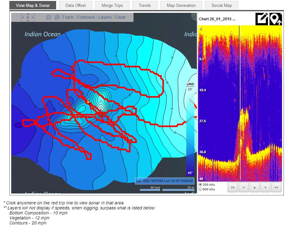
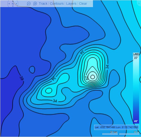
Sounder mapping of a common fishing spot.
Submitted by Jason P on Tue, 2015-01-27 21:05


As the fishing was rather crap on Monday (still better than working tho), had a go at recording and logging the sounder info at a local fishing spot to reaveal a more detailed view of the lump, actual positions.
Took about 10-15mins to log.
Used a free version of Insight Genisis to upload the data, maybe better software out there but it was free.
The contour lines are in feet, cause its american.
Was then able to upload data back to Sounder (Lowrance Elite 5 HDI) to view.
Should be rather easy to work out the spot, not that i've ever caught anything decent from there.
____________________________________________________________________________
DM306
Image Upload:


Mattyb84
Posts: 388
Date Joined: 28/12/12
That sweet mate have to give
That sweet mate have to give that a try
Pgfc member
ranmar850
Posts: 2702
Date Joined: 12/08/12
Thread resurrection time.
How do you download your logged sonar info? Can't find any option on the Elite 7 to save to card apart from that against individual trails/waypoints. And when you start logging, no option to save direct to card? We've been trying this just this afternoon on a mates' boat, planned to do it on mine as well.
bleicester
Posts: 219
Date Joined: 10/09/14
Let me guess - D9 Cockburn
Let me guess - D9 Cockburn Sound?
I've tried around there a few times also.
My 6yo had fun pulling up Wrasse and Butterfish but nothing much else. Best fish we ever go there was a 40cm Flathead.
Error 404
Fish not found
ranmar850
Posts: 2702
Date Joined: 12/08/12
Logs were saving to the sd card
Without any prompting. He got a map back from them, I went out this afternoon before the weather turned and finished logging the area, now to merge them. The beauty of this is that it is never closed off, you can just keep logging an area in ever more detail, and anything new you send them will be merged, and more detail, if detected will be added.. If you pay for Premium, you also get bottom compostion, instead of just contours.
Jason P
Posts: 521
Date Joined: 16/02/13
Sounds like you got it
Sounds like you got it worked out now, as did this a while back but couldn't remember how I did it off hand.
DM306
Heinz
Posts: 165
Date Joined: 20/06/07
Sounds sweet mate, cant wait
Sounds sweet mate, cant wait to see some pics!
Just signed up with Insight Genesis today, just gotta get back out on the water to start sonar logging. Bloody work!
ranmar850
Posts: 2702
Date Joined: 12/08/12
Have been tearing my hair out over this.
But have resolved it this afternoon. I couldn't generate a map, although all the rest of the system worked perfectly.I had been using Chrome, and when I clicked Generate Map, nothing happened. No error messages, just nothing. I finally tried using IE today, and when I clicked Generate Map, an error message came, to do with incorrect plotter ID. I checked my account, and found a #in front of the serial number I had registered. Fixed that, and maps generate no problems. I have been merging, also running single maps. looks useful.