LiDAR image of offshore bathymetry for Two Rocks
Submitted by Mick C on Fri, 2014-03-14 11:42
Came across this image and thought it may be of interest to some.
____________________________________________________________________________
Ability is what you are capable of doing. Motivation determines what you do. Attitude determines how well you do it - LH.
Image Upload:


Bruzoandnicko
Posts: 71
Date Joined: 02/07/12
Pretty cool, have you got the
Pretty cool, have you got the link? - Is there more?
Mick C
Posts: 608
Date Joined: 26/12/13
LiDAR Images
Being new to WA I have only just discovered that the DoT holds LiDAR generated bathymetry for coastal waters (the image was in a proposal request from DoT to my company to undertake a geophysical survey of the coastal reserve immediately north of the Two Rocks Marina). Light detection and ranging (LiDAR) mapping is an accepted method of generating precise and directly georeferenced spatial information about the shape and surface characteristics of the Earth. For anyone interested a LiDAR 101 explanation can be found at: http://www.csc.noaa.gov/digitalcoast/_/pdf/lidar101.pdf.
LiDAR data is expensive to obtain because it must be captured from the air by specialised equipment. A number of government agencies and private companies undertake LiDAR surveys for specific purposes and will commission the collection of LiDAR data. The data may then be purchased by others and is generally about $100 per square kilometre (assuming that it is available for your area of interest). Once purchased, it may be imported into a range of different mapping applications and manipulated and presented for specific purposes. Working with LiDAR data requires specialist knowledge and computer software.
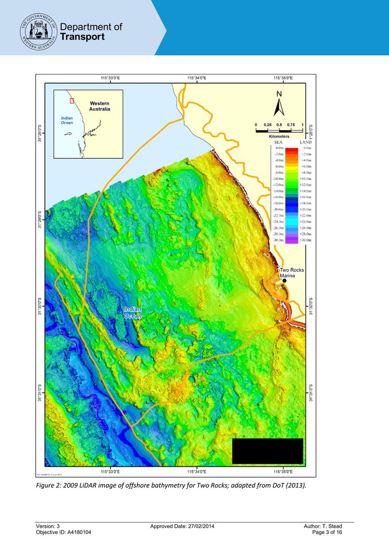
Without having a specific knowledge of the DoT LiDAR data set, I would say that it would have been captured to provide a better understanding of the offshore features of the coastline. This would be important to DoT as it regulates shipping and the like and knowledge of the sea floor would be important for a number of purposes (for example, currents in particular places are highly dependant on the shape of the sea floor). The bathymetry would have been generated by using the different colour spectrum in the captured data and calibrating this with known water depth to produce a graded image that reflects sea floor features. As always, there is an error bound that is associated with the data and this is not stated on the image (general land based LiDAR errors are about 150mm) but I would expect it to exceed land based LiDAR errors. Nevertheless, the image is a very accurate representation of the ocean floor over the area presented.
So, you can not just "log on" to a site and get easy access to LiDAR data in the format you desire. I know what most people would like for fishing purposes is a LiDAR generated image of the Perth Metro coast on a spacially referenced base that can be interpreted through a simple computer application such as Microsoft Paint (if you move the cursor over the image, coordinates are presented that reflect actual eastings and northings). I have a few contacts in DoT and will make some enquiries about the availability of its data and the format it is in. I may then be able to make a map that has the desired properties and make that available to Fishwrecked members. It is probably a "hard ask" but I will give it a crack. Barring that, I should be able to get an image of the Perth coast such as the one presented and make that available where location positions can be generally determined from the scales on the x and y axis of the image.
The technology available nowdays is quite remarkable really.
Ability is what you are capable of doing. Motivation determines what you do. Attitude determines how well you do it - LH.
big john
Posts: 8783
Date Joined: 20/07/06
Great
That would be great if you can do it Mick.
WA based manufacturer and supplier of premium leadhead jigs, fligs, bucktail jigs, 'bulletproof' soft plastic jig heads and XOS bullet jig heads.
Jigs available online in my web store!
Tradewind
Posts: 754
Date Joined: 18/09/12
Thanks for posting, would
Thanks for posting, would love to see more of the Metro coast line
Rig
Posts: 2925
Date Joined: 27/12/06
Cool
How does this work
tangles
Posts: 1367
Date Joined: 17/12/06
out wide
hows the buildup out wide on the banks! Youd be wanting some gd wx to rip out there
unhurry
Posts: 236
Date Joined: 23/10/12
neat
Welcome to WA and fishwrecked.
There is a lot of banter and also a wealth of information on this sight, and your posting presents very impressive technology. I hasd not heard of Lidar before and I can understand that it is an expensive technology to produle and process these images.
I do understand the proprietry restrictions on the availability of the data / images but I may as well ask ( nothing ventured nothing gained) that if you are making a request to "insiders" for Perth metro seafloor images, could you also ask for geographe bay particularly Bunbury area?
Thanks
carnarvonite
Posts: 8702
Date Joined: 24/07/07
Displays
Displays all of Gretel reef , the first and sec ond banks and just a touch of the Map and Malley reefs with great clarity, wonder how it would work in deeper waters
Tradewind
Posts: 754
Date Joined: 18/09/12
Did a bit of googling on it
Did a bit of googling on it and it appears the DoT have the 5x5 resolution from Two Rocks to Cape Nat
There is existing 25 x 25 res that you can download and look at already, but the 5x5 is the better resolution for finding those smaller bombies
I put in a request in by email to the person who distributes it at the DoT for personal use but i'm not holding my breath