Mapping Program- PC -Recommendations
Submitted by trueblue_10 on Mon, 2014-07-14 17:54
I want to do some mapping on my PC for transfer between my Lowrance LCX110c re routes, waypoints etc. What do you use/recommend.
It would be preferable it did not cost an arm and a leg. I brought a Navionics Gold card and are a bit disappointed that Navionics do not supply a free mapping solution for the PC to run as a standalone.
I believe they had PC App available for free a few years ago but that is no longer available and I can't get a copy of this. The web app is basic and does not let you save waypoints etc.
Image Upload:


Tim
Posts: 2497
Date Joined: 26/09/06
GDM6
You can download GDM6 from the lowrance site to manage waypoints but is very basic as far as maps go. Plus is its free
crano
Posts: 712
Date Joined: 04/11/09
I use expert gps. It does
I use expert gps. It does not cost a lot and is easy to use.You just need to save your waypoints as GPX rather than USR
spinksy
Posts: 266
Date Joined: 06/10/10
Navigation planner
Made by navionics cost $150 lets you download your plotter card onto it very good. got mine through navionics in sydney
trueblue_10
Posts: 104
Date Joined: 29/06/11
Using GDM6
Tim I am using GDM6 for entering some new waypoints. But only problem is the map is terrible (very Basic), No depths, obstacles, markers etc from what I have observed (Only the outline of the land) . Unless I am doing something wrong?
Crano I assume that the Lowrance sounders can utilise the GPX type co-ords??
richteb
Posts: 1
Date Joined: 13/07/14
Why not download garmin home
Why not download garmin home port and bluechart of the net. Home port can export in gpx or gdb format so should work on your lowarnce.
trueblue_10
Posts: 104
Date Joined: 29/06/11
Insight Planner
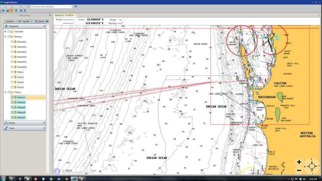
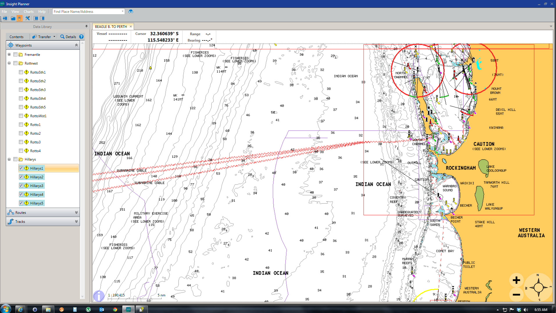
Just wanted to thank everyone and provide some feedback to everyone above as to what my research and trials resulted in.
I finally purchased Navico's Insight Planner $32AUS (A Download/online purchase). I have included a screen shot in my opening post of this application in use.
It is a fairly basic program, simple to use and so far so good as it allows me to create way points, import waypoints, routes etc plus plot, create tracks and routes etc.
The Best feature is it allows me to import and use all my the Navionics Gold card Charts. Now I can use those Charts to check against the way points for depth, terrain etc etc.
I can export out in numerous formats to suit the sounder type plus record a lot of information on this charting program relevant to each of waypoints.
I tried some of the suggestions above. ExpertGPS is very good functionally but did not let me use my Gold Card Maps and costs $74. GDM6 is free but very very basic with no charts to plot against only an outline of the land and did not suit my purpose as I wanted to be able to review each co-ordinate on a marine chart. Fugawi Marine ENC is very good does everything and latest version allows me to import my Navionics Maps but the price ($275 US) could not be justified for what I want it for. Did not try the Garmin Software.
Here is the link to Insight Planner if you want to read about it https://insightstore.navico.com/site/insight_charts/7?type=NL-IP-DL&subcategory_id=27&prod_id=298
BTW my sounder is a Lowrance LCX110C and Insight Planner works well for this. I have imported data into my sounder and no probs. Insight Planner allows me to export my data as a .GPX file, .KMZ file or .USR file (Versions 2 to Version 5) so it could fit the bill for many sounders.
All the best true
crano
Posts: 712
Date Joined: 04/11/09
Sounds interesting.Do you
Sounds interesting.Do you have to have the navionics card in your computer all the time to see charts or can you save screen shots off the card?
Septimus
Posts: 146
Date Joined: 14/11/10
NAVICO
Only problem with Insight Planner is that you have to be using a Navico (Simrad, Lowrance, etc) plotter - as part of download process you need to provide a serial number (for a "valid" plotter)?
So while you can export/import in generic formats such as GPX, not sure how you get around the plotter issue?
trueblue_10
Posts: 104
Date Joined: 29/06/11
Not True
Sorry Septimus what you suggest is not correct. I did not provide a serial number as I do not have one of those plotters as per the Navico list. My sounder/GPS is an old LCX110c so I could not provide one. (I had read elsewhere I could do this).
When you purchase the software they send you an email with the serial key. You then download the software and enter the key it functions well.
I just downloaded the latest version of the software (went for beta version) when any question came up regarding serial keys for HDS sounders etc I left then blank or did not answer. They still gave me access to the software and provides a serial key for the software.
Further you can import and export waypoints etc in .USR (version 2 to 5), .GPX and .KMZ which will suit most GPS units I would think. Certainly suits all Lowrance plotters.
As for the Navionics card -No once the mapos are loaded (which is easy to do)it no longer needs the card. But it will only take Gold Maps etc that are made later than early 2010 (I will research this and give an exact date if you like. Think it is Jan or Feb 2010.)
trueblue_10
Posts: 104
Date Joined: 29/06/11
Insight planner
The exact maps that can be imported are :
Charts from the Insight Store BSB version 1 through 5 including NOAA RNC.
Vector S-57 including NOAA ENC. Vector S-63 with valid cell permit.
Navionics Gold, Platinum+, HotMaps Premium charts on media cards. Must be nTagenabled (Navionics cards manufactured after April 2010).
nv-charts, CHS, Maptech™, Swedish Marine Charts. and more!
My navionics card was purchased last year so I had no issue with loading the maps.
Septimus
Posts: 146
Date Joined: 14/11/10
SORRY
My mistake - read that off their website.
But, called them up and sure enough, they do send you a serial number that does the trick.
I have been using Insight Planner for the last couple of days and like it for the price and limited functionality I was after.
Only thing that has me a little worried after mucking around with it, is the potential for the developer to harvest waypoints?
What's with "cloud based" backups of your waypoints?
trueblue_10
Posts: 104
Date Joined: 29/06/11
Backups
Haven't looked into the backups to much. Not sure it does this by default. Like you I would not like backing up via the cloud. I will sus this out a bit more. Currently just backing up via export of my waypoints, routes etc onto a hard drive as a .usr file. Easy enough to reinstall maps and then import the .usr data if a crash or corruption occurs.
i actually emailed navico 2 days ago suggesting they some have a save function on the application so you can have progressive saves as you enter a heap of data. Otherwise memory overflow issues can cause problems. This will provide some improved redundancy than current as it seems the data is saved on exit of the program so if it crashes you may lose data not saved.
also for your info the all the map data (not the maps), waypoints, routes etc are stored in the hidden app data file so if you have issues and want to start fresh you have to delete the files in that location.
Nealez
Posts: 1220
Date Joined: 08/05/06
Have an Elite-5 DSI as a
Have an Elite-5 DSI as a plotter.. compatability shouldnt be an issue considerings its still a 5 yeah?
trueblue_10
Posts: 104
Date Joined: 29/06/11
Insight Planner
Yep should be no problems at all. Ensure you buy from the Navico site ($29.99 US). You will have to provide your credit card details. They will then send you an email with the serial key. https://insightstore.navico.com/site/insight_charts/7?type=NL-IP-DL&subcategory_id=27&prod_id=298
Lowrance sells the same version for about $50.
Nealez my recommendation is to download and install the latest Beta version (version 1.1.0.11) it loads maps a lot faster and seems more stable. I tried the latest normal download (Ver 1.0.0.79) but it is not as good as the Beta version. Here is the download site for both full versions of the software https://insightstore.navico.com/software .
With your elite 5 may also want to try entering your serial key of your plotter/sounder during purchase/registration. If it does not like it do not panic you still go through with the sale enter only lowrance as you sounder provide your details and email address and credit card details. You will then get 2 emails one will be the serial key for the software.
Just be mindful as per my previous post if you are relying on using your Navionics Maps with the program the maps must be Navionics cards manufactured after April 2010. It will take Navionics Gold, Platinum+, HotMaps Premium charts on media cards. If Navionics gave you a small card reader with your maps (which mine did- Navionics Gold purchased last year) I recommend you using that for the import of the maps.
Hopefully this is not to confusing. Hope this helps everyone. Anyone can PM me if you want to ask me a few questions outside this forum.
BTW I can ensure everyone I am not in any way associated with Navionics, Lowrance or Navico. This was the result of my desperate search, researching and testing of a suitable PC charting program for integration with my Navionics Gold maps that was not going to cost an arm and a leg. I just though I would share it with you all.
Just an aside it seems that Insight Planner may have been designed by Fugawi for Navico. I actually tested a trial full Fugawi Marine ENC program it is bloody good but cost $279 US. Anyone who has used a Fugawi mapping/charting program I guess would probably attest as to its quality so I was hoping the same sort of love and care went into Insight Planner (be it it a much more simplified version for charting for $30).
Septimus
Posts: 146
Date Joined: 14/11/10
WPT HARVESTING?
Anything further on above concern?
trueblue_10
Posts: 104
Date Joined: 29/06/11
Fugawi Replied re Insight Planner
----
Here is Fugawi's response to the backup via the cloud question. I have copied and pasted their reply. I gave him the hyperlink to this topic to view. I also had a manual backup enquiry of the program which may be of interest to this forum. Trueblue_10
"Hi
Thank you for the email. I read through the blog and I can understand the concern about such things (Waypoint Harvesting).
At Fugawi we are very very careful about protecting the data of customers. We have a lot of customers all over the world many of whom similar to you guys have data for Fishing, Drilling, racing etc. different reasons. The point is every customer wishes to keep their data private.
That is why the Insight Planner cannot and will not do any cloud based AUTO backing up. So at no point does any of your data come to us in any possible way. The Insight Planner can do two things for data back up and i want to elaborate clearly for everyone.
1. When you are creating Waypoints and Routes on the Insight Planner. Everything is getting saved to your PC in real time at this location here.
C:\Users\<>\AppData\Roaming\Insight Planner\
2. If you wish to save these planned routes, waypoints or tracks to take over to your chart plotter or GPS device, you have to simply export them out in GPX, KMZ or USR. Now we give you two options for this.
a. You can create the file on your PC. Then manually copy the file (GPX,USR or KMZ) to your GPS or Chart Plotter.
b. You can create a file that is saved directly to your Insight store account.
Option A is normal and can be done in most software. In Option B the file is uploaded to a data account on the Insight store. Using this option you don't have to carry files around with you. You can simply download the file off that account at any place where you have an internet connection. Making it fast and easy for people to shift data around. If the data is sensitive and you wish to keep in only on your PC, you can continue to use Option A. Option B is merely a convenience for customers.
So to answer your question, we the developers of the software cannot look at whats on your library on your PC. There is no auto cloud system back up. The only option close to that is Option B where you must choose yourself to upload these files to a Insight Store account manually. If you don't, the files will never leave your PC system.
You can copy this or if you wish to explain in fewer words to the other members you can totally do this.
Finally for the manual backup. We were actually debating implementing a system like this for our software. For now its not on board but if you wish to have piece of mind, you can export all the library data in GPX format. I know it may be a little bit more cumbersome but I will definitely add your suggestion to our wish list and pass it on to the developers and see if we make can make it happen.
I hope this helps. Thank you for putting in a good word for us on the forums. The one thing you can rest assured with our software is that you will always get the support you need to get things done.
Best Regards,
Sheldon Foulds
Software Support Specialist
Northport Systems Inc.
60 St. Clair Ave. East, Suite 902
Toronto, Ontario
M4T 1N5
CANADA"
trueblue_10
Posts: 104
Date Joined: 29/06/11
Sent Your Enquiry to Navico
Septimus I have been dealing with Software Support Specialist in Canada for Insight Planner in regards to some suggestions and improvements.
Tonight I emailed him your enquiry. I will let you know his reply. I also invited him to join this forum and provided the hyperlink to this topic. I will update this forum if or when I get a reply.
trueblue_10
Posts: 104
Date Joined: 29/06/11
Insight Planner - Reply from Fugawi Support Specialist
Here is Fugawi's response to the backup via the cloud question. I have copied and pasted their reply. I gave him the hyperlink to this topic to view. I also had a manual backup enquiry of the program which may be of interest to this forum. Trueblue_10
"Hi
Thank you for the email. I read through the blog and I can understand the concern about such things (Waypoint Harvesting).
At Fugawi we are very very careful about protecting the data of customers. We have a lot of customers all over the world many of whom similar to you guys have data for Fishing, Drilling, racing etc. different reasons. The point is every customer wishes to keep their data private.
That is why the Insight Planner cannot and will not do any cloud based AUTO backing up. So at no point does any of your data come to us in any possible way. The Insight Planner can do two things for data back up and i want to elaborate clearly for everyone.
1. When you are creating Waypoints and Routes on the Insight Planner. Everything is getting saved to your PC in real time at this location here.
C:\Users\<>\AppData\Roaming\Insight Planner\
2. If you wish to save these planned routes, waypoints or tracks to take over to your chart plotter or GPS device, you have to simply export them out in GPX, KMZ or USR. Now we give you two options for this.
a. You can create the file on your PC. Then manually copy the file (GPX,USR or KMZ) to your GPS or Chart Plotter.
b. You can create a file that is saved directly to your Insight store account.
Option A is normal and can be done in most software. In Option B the file is uploaded to a data account on the Insight store. Using this option you don't have to carry files around with you. You can simply download the file off that account at any place where you have an internet connection. Making it fast and easy for people to shift data around. If the data is sensitive and you wish to keep in only on your PC, you can continue to use Option A. Option B is merely a convenience for customers.
So to answer your question, we the developers of the software cannot look at whats on your library on your PC. There is no auto cloud system back up. The only option close to that is Option B where you must choose yourself to upload these files to a Insight Store account manually. If you don't, the files will never leave your PC system.
You can copy this or if you wish to explain in fewer words to the other members you can totally do this.
Finally for the manual backup. We were actually debating implementing a system like this for our software. For now its not on board but if you wish to have piece of mind, you can export all the library data in GPX format. I know it may be a little bit more cumbersome but I will definitely add your suggestion to our wish list and pass it on to the developers and see if we make can make it happen.
I hope this helps. Thank you for putting in a good word for us on the forums. The one thing you can rest assured with our software is that you will always get the support you need to get things done.
Best Regards,
Sheldon Foulds
Software Support Specialist
Northport Systems Inc.
60 St. Clair Ave. East, Suite 902
Toronto, Ontario
M4T 1N5
CANADA"
Septimus
Posts: 146
Date Joined: 14/11/10
CLUNKY PIECE OF CRAP!!
Well, I bought this software and tried it, as mentioned in a previous post.
It would crash intermittently, but, I put up with it.
Then I got an email telling me that a free update was available that would fix a lot of the issues, so I downloaded it and guess what - it now crashes on start up EVERYTIME!!!???
Sent an email to "Support" over a week ago and still no answer - should've known better than to bother with anything associated with Navico.
trueblue_10
Posts: 104
Date Joined: 29/06/11
Crashes
Hello Septimus - sorry to hear - Did they ever get back to you? I have downloaded the latest update and given your post I may not try installing given I have heaps of co-ordinates on mine. I have earlier versions of this program downloaded including 1.1.0.11 if you took a backup of the co-ordinates before you upgraded/it crashed then I can send you the earlier programs and you can hopefully re-install.
FYI mine crashes intermittently as well (usually reports a memory problem) but I still use this program a fair bit and have installed it on a 2nd laptop for portability. For my purposes it does ok and for $30 it cost I can put up with the intermittent crashes unless someone can give me a better alternative for about the same price?
Kristof
Posts: 30
Date Joined: 27/03/14
Mapping Program- PC -Recommendations
I was doing some research on this topic and was thinking about asking for advice on the forum , so all of the above ideas help.
Cheers
Kristof